Sunday, February 26, 2017

Explore Canada's Parks and Trails


Thanks to the Parks Canada collaboration with Google, you can now explore many Parks Canada places within Street View for Google Maps.

 Parks Canada places currently within Street View


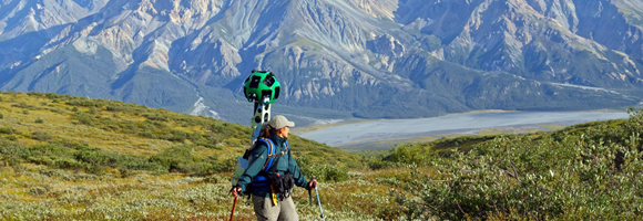
Some of the great trails to google trek...

Soldier's Summit Trail, Kluane National Park, Yukon Territory


Chilkoot Trail 
Follow the fabled Chilkoot Trail along the centuries old path first crossed by Chilkoot Tlingit traders and later stormed by the Klondike Gold Rush stampeders. Hike through narrow windswept valleys and scale the precipitous Chilkoot Pass...

Start at the Trail Head


Friday, February 3, 2017

Amazonia: Boating Down River


The Google Amazon Project provides an exciting opportunity to go boating on the Rio Negro River and explore the waterways of the Amazon jungle...

Trek the Amazon Basin with Google Maps


The journey takes place in the heart of Amazonia


On the El Negro River east of Manaus


You cruise down the El Negro River

Then explore waterways through the Amazon jungle


Thursday, February 2, 2017

Grand Canyon Trail and River

Google Street View is also a great way to explore the Grand Canyon. You can use it to hike the famous Bright Angel Trail and admire the awesome scenery... 


 Go to Google Streetview Bright Angel Trail


 You can also go boating through the Canyon down the Colorado River...


Inca Mountain city of Machu Picchu, Peru

 A good way to stroll around Machu Picchu without the altitude sickness...


Hike the Samaria Gorge in Crete


An amazing hike down the Samaria Gorge in Crete to the sea...


Underwater wonders at Cape Kri, Raja Ampat, Indonesia

Some amazing sights to see while diving off Cape Kri, Raja Ampat, Indonesia...


Famous Islands: Galápagos Islands

Bartolome Island


Using Google Streetview to visit the famous Galápagos Islands off the coast of Equador, South America...


Darwin in the Galapagos 

National Geographic Wild


Galapagos Islands by drone - 4K Ultra HD


Explore the Galapagos Islands with Google Maps


Galapagos Islands National Geographic Expeditions | (Ecuador) Our Awesome Planet Vlog (Part I)


Galapagos Islands National Geographic Expeditions | (Ecuador) Our Awesome Planet Vlog (Part 2)


On the following map you will see the locations we will visit marked and numbered in red, and we hope to add more locations:


1.  NORTH SEYMOUR ISLAND


 Visit a mother seal and her pup 
then head out onto the beach on North Seymour Island


2.  CHAMPION ISLET

off Champion Islet... 


Wednesday, February 1, 2017

Atop the Eiffel Tower

And who would want to miss the view of Paris from atop the Eiffel Tower. You can walk around and take in the panorama from all sides..


Exploring the Coastal Trail on the Italian Cinque Terre

Another great place for virtual travellers is the town of Manarola on the Italian Cinque Terre. You can stroll through town and walk some of the amazing coastal trail:


Or head out the other side of Manarola and walk the coastal trail to Riomaggiore:


Google Skydiving Over Abel Tasman, New Zealand

Took time off from my trek on the Kepler Track to go skydiving over Abel Tasman... Go to Google Street View of Skydiving Over Abel Tasman


Pilot gives his thumbs up. It is time to jump! But hey, shouldn't you be flying the plane?!!!

Taking some time to admire the view before jumping.

And I'm off! The parachute is open and I have begun my glide down.

The views are amazing!

Looking down over the town. You can see the landing field in this picture. It is the square slightly below center.

Looking north to Abel Tasman National Park.

Looking across at Abel Tasman National Park on the upper coast of the South island.

Looking out across the strait towards the North Island in the far distance. The land to the right is just the other side of the bay.

Gliding lower. Now where was that landing field?


That little dot in the sky is the next skydiver coming in behind me.

There's the landing field, I think...


Prepare for landing!

Perfect landing first time! 

Kepler Track Google-Trek Part 3

I continue my google trek on the Kepler Track heading down from Luxmore Hut to Brod Bay on Lake Te Anau...  


Map showing the trek from Luxmore Hut to Brod Bay

Looking back at Luxmore Hut as I start on my way.

Looks like I'll be into the woods soon.

A last view of Luxmore Hut.

Still a way to go before I get to the forest.

Still great views over the lake and mountains.


Fellow trekers on the way.


These two don't seen too interested in the scenery.


Down we go and into the woods.

Been hiking for 45 minutes.

Track through the woods with many switchbacks as we descend to the lake.


Passing some awesome cliffs reminding me a bit of the Bruce Trail near Tobermory.


Nice to see some ferns again after the barren mountain track.

Glmpsing the lake again through the trees.

Finally down at lake level and heading out to the beach at Brod Bay...

The beach at Brod Bay on Lake Te Anau. Not too crowded!


Looking the other way down the beach at Brod Bay on Lake Te Anau. There is a campground at Brod Bay.


The end of another fine day of treking the Kepler Trail.

Famous Castles Series

  Explore some of the great castles of the world: Framlingham Castle, Suffolk Chillon Castle, Switzerland Orava Castle, Slovakia Almourol Ca...